Africa
Ethiopia
Asia
Afghanistan
Armenia
Indonesia
Japan
Philippines
Russia
Turkey
Europe
France
Greece
North America
Canada
Grenada
Mexico
United States
- Augustine Volcano, Cook Inlet, Alaska
- Lassen Peak, Shasta County, California
- Mono-Inyo Craters, California
- Panum Crater, California
- Newberry Volcano, Oregon
- West Crater, Washington
- Novarupta, Alaska
- Black Butte, Siskiyou County
- Chaos Crags
- Coso Volcanic Field
- Mammoth Mountain, Inyo National Forest
- Sutter Buttes, Sacramento Valley
- Big Southern Butte, Butte County, Idaho
- Cinnamon Butte, Oregon
- Marble Mountain-Trout Creek Hill, Washington
- Mount Elden, Coconino County, Arizona
- Steamboat Springs, Washoe County, Nevada
- Salton Buttes, Salton Sea, California
South America
Argentina
Bolivia
Chile
Oceania
New Zealand
Australia
Explosive eruption of
Sinabung on 9 June 2019.
-
-
Sunda Strait and Java
The
Sunda Strait separates the islands of Sumatra and
Java with the volcanic island
Krakatoa lying between them. Krakatau erupted violently in 1883, destroying two-thirds of the island and leaving a large
caldera under the sea. This cataclysmic explosion was heard as far away as the island of
Rodrigues near
Mauritius (approx. 4,800 kilometres (3,000 mi) away).
[1] A new
parasitic cone, called Anak Krakatau (or the child of Krakatau), rose from the sea at the centre of the caldera in 1930.
[13] The other Krakatau
islets from the 1883 eruptions are known as Sertung, Panjang and Rakata.
Java is a relatively small island compared to Sumatra, but
it has a higher concentration of active volcanoes. There are 45 active volcanoes on the island excluding 20 small
craters and
cones in the
Dieng volcanic complex and the young cones in the
Tengger caldera complex. Some volcanoes are grouped together in the list below because of their close location.
Mount Merapi,
Semeru and
Kelud are the most active volcanoes in Java. Mount Semeru has been continuously erupting since 1967.
[14] Mount Merapi has been named as one of the
Decade Volcanoes since 1995.
[15] Ijen has a unique colourful
caldera lake which is an extremely acidic natural reservoir (
pH<0.3).
[16] There are sulfur mining activities at Ijen, where miners collect highly concentrated sulfur rocks by hand.
| Krakatau |
caldera |
813 metres (2,667 ft) |
2019 (ongoing) |
 6.102°S 105.423°E 6.102°S 105.423°E
|
| Pulosari |
stratovolcano |
1,346 metres (4,416 ft) |
unknown |
6.342°S 105.975°E
|
| Gunung Karang |
stratovolcano |
1,778 metres (5,833 ft) |
unknown |
6.27°S 106.042°E
|
| Kiaraberes-Gagak |
stratovolcano |
1,511 metres (4,957 ft) |
6 April 1939 (1) |
6.73°S 106.65°E
|
| Perbakti |
stratovolcano |
1,699 metres (5,574 ft) |
unknown |
6.75°S 106.68°E
|
| Salak |
stratovolcano |
2,211 metres (7,254 ft) |
31 January 1938 (2) |
6.72°S 106.73°E
|
| Gede |
stratovolcano |
2,958 metres (9,705 ft) |
13 March 1957 (2) |
6.78°S 106.98°E
|
| Patuha |
stratovolcano |
2,434 metres (7,986 ft) |
unknown |
7.160°S 107.40°E
|
| Wayang-Windu |
lava dome |
2,182 metres (7,159 ft) |
unknown |
7.208°S 107.63°E
|
| Malabar |
stratovolcano |
2,343 metres (7,687 ft) |
unknown |
7.13°S 107.65°E
|
| Tangkuban Perahu |
stratovolcano |
2,084 metres (6,837 ft) |
26 June 2019 (1) |
6.77°S 107.60°E
|
| Papandayan |
stratovolcano |
2,665 metres (8,743 ft) |
11 November 2002 (2) |
7.32°S 107.73°E
|
| Kendang |
stratovolcano |
2,608 metres (8,556 ft) |
unknown |
7.23°S 107.72°E
|
| Kamojang |
stratovolcano |
1,730 metres (5,680 ft) |
Pleistocene |
7.125°S 107.80°E
|
| Guntur |
complex volcano |
2,249 metres (7,379 ft) |
16 October 1847 (2) |
7.143°S 107.840°E
|
| Tampomas |
stratovolcano |
1,684 metres (5,525 ft) |
unknown |
6.77°S 107.95°E
|
| Galunggung |
stratovolcano |
2,168 metres (7,113 ft) |
9 January 1984 (1) |
7.25°S 108.058°E
|
| Talagabodas |
stratovolcano |
2,201 metres (7,221 ft) |
unknown |
7.208°S 108.07°E
|
| Karaha |
fumarole |
1,155 metres (3,789 ft) |
unknown |
7.12°S 108.08°E
|
| Cereme |
stratovolcano |
3,078 metres (10,098 ft) |
1951 |
6.892°S 108.40°E
|
| Slamet |
stratovolcano |
3,432 metres (11,260 ft) |
2014 |
7.242°S 109.208°E
|
| Dieng |
complex volcano |
2,565 metres (8,415 ft) |
2018 (1) |
7.20°S 109.92°E
|
| Sundoro |
stratovolcano |
3,136 metres (10,289 ft) |
29 October 1971 (2) |
7.30°S 109.992°E
|
| Sumbing |
stratovolcano |
3,371 metres (11,060 ft) |
1730 (?) |
7.384°S 110.070°E
|
| Ungaran |
stratovolcano |
2,050 metres (6,730 ft) |
unknown |
7.18°S 110.33°E
|
| Telomoyo |
stratovolcano |
1,894 metres (6,214 ft) |
unknown |
7.37°S 110.40°E
|
| Merbabu |
stratovolcano |
3,145 metres (10,318 ft) |
1797 (2) |
7.45°S 110.43°E
|
| Merapi |
stratovolcano |
2,968 metres (9,738 ft)
|
2019 (ongoing)
|
7.542°S 110.442°E
|
| Muria |
stratovolcano |
1,625 metres (5,331 ft) |
160 BC ± 30 years |
6.62°S 110.88°E
|
| Lawu |
stratovolcano |
3,265 metres (10,712 ft) |
28 November 1885 (1) |
7.625°S 111.192°E
|
| Wilis |
stratovolcano |
2,563 metres (8,409 ft) |
unknown |
7.808°S 111.758°E
|
| Kelud |
stratovolcano |
1,731 metres (5,679 ft) |
13 February 2014 (4) |
7.93°S 112.308°E
|
| Kawi-Butak |
stratovolcano |
2,651 metres (8,698 ft) |
unknown |
7.92°S 112.45°E
|
| Arjuno-Welirang |
stratovolcano |
3,339 metres (10,955 ft) |
15 August 1952 (0) |
7.725°S 112.58°E
|
| Penanggungan |
stratovolcano |
1,653 metres (5,423 ft) |
unknown |
7.62°S 112.63°E
|
| Malang Plain |
maar |
680 metres (2,230 ft) |
unknown |
8.02°S 112.68°E
|
| Semeru |
stratovolcano |
3,676 metres (12,060 ft) |
2019 (ongoing) |
8.108°S 112.92°E
|
| Bromo |
stratovolcano |
2,329 metres (7,641 ft) |
2019
|
7.942°S 112.95°E
|
| Lamongan |
stratovolcano |
1,651 metres (5,417 ft) |
5 February 1898 (2) |
7.979°S 113.342°E
|
| Lurus |
complex volcano |
539 metres (1,768 ft) |
unknown |
7.73°S 113.58°E
|
| Iyang-Argapura |
complex volcano |
3,088 metres (10,131 ft) |
unknown |
7.97°S 113.57°E
|
| Raung |
stratovolcano |
3,332 metres (10,932 ft) |
29 June 2015 (?) |
8.125°S 114.042°E
|
| Ijen |
stratovolcano |
2,799 metres (9,183 ft) |
28 June 1999 (1) |
8.058°S 114.242°E
|
| Baluran |
stratovolcano |
1,247 metres (4,091 ft) |
unknown |
7.85°S 114.37°E |
| Weh |
stratovolcano |
617 metres (2,024 ft) |
Pleistocene |
5.82°N 95.28°E
|
| Seulawah Agam |
stratovolcano |
1,810 metres (5,940 ft) |
1839 (2) |
5.448°N 95.658°E
|
| Peuet Sague |
complex volcano |
2,801 metres (9,190 ft) |
25 December 2000 (2) |
4.914°N 96.329°E
|
| Geureudong |
stratovolcano |
2,885 metres (9,465 ft) |
1937 |
4.813°N 96.82°E
|
| Kembar |
shield volcano |
2,245 metres (7,365 ft) |
Pleistocene |
3.850°N 97.664°E
|
| Sibayak |
stratovolcano |
2,212 metres (7,257 ft) |
unknown |
3.23°N 98.52°E
|
| Sinabung |
stratovolcano |
2,460 metres (8,070 ft) |
9 June 2019 (2)[12] |
3.17°N 98.392°E
|
| Toba |
supervolcano |
2,157 metres (7,077 ft) |
72000 BC |
2.58°N 98.83°E
|
| Helatoba-Tarutung |
fumarole field |
1,100 metres (3,600 ft) |
Pleistocene |
2.03°N 98.93°E
|
| Imun |
unknown |
1,505 metres (4,938 ft) |
unknown |
2.158°N 98.93°E
|
| Sibualbuali |
stratovolcano |
1,819 metres (5,968 ft) |
unknown |
1.556°N 99.255°E
|
| Lubukraya |
stratovolcano |
1,862 metres (6,109 ft) |
unknown |
1.478°N 99.209°E
|
| Sorikmarapi |
stratovolcano |
2,145 metres (7,037 ft) |
1986 (1) |
0.686°N 99.539°E
|
| Talakmau |
complex volcano |
2,919 metres (9,577 ft) |
unknown |
0.079°N 99.98°E
|
| Sarik-Gajah |
volcanic cone |
unknown |
unknown |
0.008°N 100.20°E
|
| Marapi |
complex volcano |
2,891 metres (9,485 ft) |
2018
|
0.381°S 100.473°E
|
| Tandikat |
stratovolcano |
2,438 metres (7,999 ft) |
1924 (1) |
0.433°S 100.317°E
|
| Talang |
stratovolcano |
2,597 metres (8,520 ft) |
12 April 2005 (2) |
0.978°S 100.679°E
|
| Kerinci |
stratovolcano |
3,800 metres (12,500 ft) |
2019 (on going)
|
1.697°S 101.264°E
|
| Hutapanjang |
stratovolcano |
2,021 metres (6,631 ft) |
unknown |
2.33°S 101.60°E
|
| Sumbing |
stratovolcano |
2,507 metres (8,225 ft) |
23 May 1921 (2) |
2.414°S 101.728°E
|
| Kunyit |
stratovolcano |
2,151 metres (7,057 ft) |
unknown |
2.592°S 101.63°E
|
| Pendan |
unknown |
unknown |
unknown |
2.82°S 102.02°E
|
| Belirang-Beriti |
compound |
1,958 metres (6,424 ft) |
unknown |
2.82°S 102.18°E
|
| Bukit Daun |
stratovolcano |
2,467 metres (8,094 ft) |
unknown |
3.38°S 102.37°E
|
| Kaba |
stratovolcano |
1,952 metres (6,404 ft) |
22 August 2000 (1) |
3.52°S 102.62°E
|
| Dempo |
stratovolcano |
3,173 metres (10,410 ft) |
2018 (1) |
4.03°S 103.13°E
|
| Patah |
unknown |
2,817 metres (9,242 ft) |
unknown |
4.27°S 103.30°E
|
| Bukit Lumut Balai |
stratovolcano |
2,055 metres (6,742 ft) |
unknown |
4.23°S 103.62°E
|
| Besar |
stratovolcano |
1,899 metres (6,230 ft) |
April 1940 (1) |
4.43°S 103.67°E
|
| Ranau |
caldera |
1,881 metres (6,171 ft) |
unknown |
4.83°S 103.92°E
|
| Sekincau Belirang |
caldera |
1,719 metres (5,640 ft) |
unknown |
5.12°S 104.32°E
|
| Suoh |
caldera |
1,000 metres (3,300 ft) |
10 July 1933 (4) |
5.25°S 104.27°E
|
| Hulubelu |
caldera |
1,040 metres (3,410 ft) |
1836 |
5.35°S 104.60°E
|
| Rajabasa |
stratovolcano |
1,281 metres (4,203 ft) |
1798 |
5.78°S 105.625°E
|
| Merbuk |
Bali |
tba |
1,386 metres (4,547 ft) |
unknown |
-
|
| Bratan |
Bali |
caldera |
2,276 metres (7,467 ft) |
unknown |
8.28°S 115.13°E
|
| Batur |
Bali |
caldera |
1,717 metres (5,633 ft) |
2000 (1) |
8.242°S 115.375°E
|
| Agung |
Bali |
stratovolcano |
3,031 metres (9,944 ft) |
2019 (ongoing) |
8.342°S 115.508°E
|
| Samalas |
Lombok |
stratovolcano |
2,867 metres (9,406 ft) |
1257 (7) |
8.41°S 116.40°E
|
| Rinjani |
Lombok |
stratovolcano |
3,726 metres (12,224 ft) |
2016 (2) |
8.42°S 116.47°E
|
| Tambora |
Sumbawa |
stratovolcano |
2,722 metres (8,930 ft) |
1967 ± 20 years (0) |
8.25°S 118.00°E
|
| Sangeang Api |
Sangeang |
complex volcano |
1,949 metres (6,394 ft) |
2019 (ongoing) |
8.20°S 119.07°E
|
| Wai Sano |
Flores |
caldera |
903 metres (2,963 ft) |
unknown |
8.72°S 120.02°E
|
| Poco Leok |
Flores |
unknown |
1,675 metres (5,495 ft) |
unknown |
8.68°S 120.48°E
|
| Ranakah |
Flores |
lava dome |
2,100 metres (6,900 ft) |
March 1991 (1) |
8.62°S 120.52°E
|
| Inierie |
Flores |
stratovolcano |
2,245 metres (7,365 ft) |
8050 BC |
8.875°S 120.95°E
|
| Inielika |
Flores |
complex volcano |
1,559 metres (5,115 ft) |
11 January 2001 (2) |
8.73°S 120.98°E
|
| Ebulobo |
Flores |
stratovolcano |
2,124 metres (6,969 ft) |
27 February 1969 (2) |
8.82°S 121.18°E
|
| Iya |
Flores |
stratovolcano |
637 metres (2,090 ft) |
27 January 1969 (3) |
8.897°S 121.645°E
|
| Sukaria |
Flores |
caldera |
1,500 metres (4,900 ft) |
unknown |
8.792°S 121.77°E
|
| Ndete Napu |
Flores |
fumarole |
750 metres (2,460 ft) |
unknown |
8.72°S 121.78°E
|
| Kelimutu |
Flores |
complex volcano |
1,639 metres (5,377 ft) |
3 June 1968 (1) |
8.77°S 121.82°E
|
| Paluweh |
Palu'e |
stratovolcano |
875 metres (2,871 ft) |
3 February 1985 (1) |
8.32°S 121.708°E
|
| Egon |
Flores |
stratovolcano |
1,703 metres (5,587 ft) |
2008 |
8.67°S 122.45°E
|
| Ilimuda |
Flores |
stratovolcano |
1,100 metres (3,600 ft) |
unknown |
8.478°S 122.671°E
|
| Lewotobi |
Flores |
stratovolcano |
1,703 metres (5,587 ft) |
30 May 2003 (2) |
8.542°S 122.775°E
|
| Leroboleng |
Flores |
complex volcano |
1,117 metres (3,665 ft) |
26 June 2003 (3) |
8.358°S 122.842°E
|
| Riang Kotang |
Flores |
fumarole |
200 metres (660 ft) |
unknown |
8.30°S 122.892°E
|
| Iliboleng |
Adonara Island |
stratovolcano |
1,659 metres (5,443 ft) |
June 1993 (1) |
8.342°S 123.258°E
|
| Lewotolo |
Lembata |
stratovolcano |
1,423 metres (4,669 ft) |
15 December 1951 (2) |
8.272°S 123.505°E
|
| Ililabalekan |
Lembata |
stratovolcano |
1,018 metres (3,340 ft) |
unknown |
8.55°S 123.38°E
|
| Iliwerung |
Lembata |
complex volcano |
1,018 metres (3,340 ft) |
22 May 1999 (0) |
8.53°S 123.57°E
|
| Batu Tara |
Komba island |
stratovolcano |
748 metres (2,454 ft) |
2007-15 (2) |
7.792°S 123.579°E
|
| Sirung |
Pantar Island |
complex volcano |
862 metres (2,828 ft) |
2015 (2) |
8.508°S 124.13°E
|
| Yersey |
- |
submarine |
−3,800 metres (−12,500 ft) |
unknown |
7.53°S 123.95°E
|
-
-
One of three different coloured lakes of
Kelimutu
Banda Sea
The
Banda Sea in the south of the
Molucca archipelago includes a small
group of islands. Three major
tectonic plates beneath the sea,
Eurasian,
Pacific and
Indo-Australian plates, have been converging since the
Mesozoic epoch.
[18] Volcanoes in the Banda Sea are mainly
islands, but some are
submarine volcanoes.
Sulawesi and Sangihe Islands
Four
peninsulas dominate the shape of
Sulawesi
island (formerly known as Celebes). The central part is a high
mountainous area, but mostly non-volcanic. Active volcanoes are found in
the northern peninsula and continuously stretch to the north to
Sangihe Islands. The Sangihe Islands mark the border with the
Philippines.
| Colo |
stratovolcano |
507 metres (1,663 ft) |
18 July 1983 (4) |
0.17°S 121.608°E
|
| Ambang |
complex volcano |
1,795 metres (5,889 ft) |
1845 ± 5 years |
0.75°N 124.42°E
|
| Soputan |
stratovolcano |
1,784 metres (5,853 ft) |
December 2018 |
1.108°N 124.73°E
|
| Sempu |
caldera |
1,549 metres (5,082 ft) |
unknown |
1.13°N 124.758°E
|
| Tondano |
caldera |
1,202 metres (3,944 ft) |
unknown |
1.23°N 124.83°E
|
| Lokon-Empung |
stratovolcano |
1,580 metres (5,180 ft) |
2015 |
1.358°N 124.792°E
|
| Mahawu |
stratovolcano |
1,324 metres (4,344 ft) |
16 November 1977 (0) |
1.358°N 124.858°E
|
| Klabat |
stratovolcano |
1,995 metres (6,545 ft) |
unknown |
1.47°N 125.03°E
|
| Tongkoko |
stratovolcano |
1,149 metres (3,770 ft) |
1880 (1) |
1.52°N 125.20°E
|
| Ruang |
stratovolcano |
725 metres (2,379 ft) |
25 September 2002 (4) |
2.30°N 125.37°E
|
| Karangetang |
stratovolcano |
1,784 metres (5,853 ft) |
2019 (ongoing) |
2.78°N 125.40°E
|
| Banua Wuhu |
submarine |
−5 metres (−16 ft) |
18 July 1919 (3) |
3.138°N 125.491°E
|
| Awu |
stratovolcano |
1,320 metres (4,330 ft) |
2 June 2004 (2) |
3.67°N 125.50°E
|
| Submarine 1922 |
submarine |
−5,000 metres (−16,000 ft) |
unknown |
3.97°N 125.17°E
|
Vuurberg (Dutch: fire mountain, Gunung Api) in
Bandanaira
Halmahera
Halmahera island in the north of
Molucca archipelago has been formed by the movement of three
tectonic plates resulting in two intersecting mountain ranges, which form four rocky peninsulas separated by three deep bays. A
volcanic arc stretches from north to south in the west side of Halmahera, some of which are
volcanic islands, for instance,
Gamalama and
Tidore. Gamalama's island name is
Ternate and it has been the centre for
spice trading since the
Portuguese Empire opened a
fort in 1512. Due to its location as the centre for spice trading during the
Age of Discovery, historical records of volcanic eruptions in Halmahera have been available as far back as the early 16th century.
| Tarakan |
pyroclastic cone |
318 metres (1,043 ft) |
unknown |
1.83°N 127.83°E
|
| Dukono |
complex volcano |
1,335 metres (4,380 ft) |
1933-2019 (ongoing) |
1.68°N 127.88°E
|
| Tobaru |
unknown |
1,035 metres (3,396 ft) |
unknown |
1.63°N 127.67°E
|
| Ibu |
stratovolcano |
1,325 metres (4,347 ft) |
2008-19 (ongoing) |
1.488°N 127.63°E
|
| Gamkonora |
stratovolcano |
1,635 metres (5,364 ft) |
9 July 2007 (?) |
1.38°N 127.53°E
|
| Todoko-Ranu |
caldera |
979 metres (3,212 ft) |
unknown |
1.25°N 127.47°E
|
| Jailolo |
stratovolcano |
1,130 metres (3,710 ft) |
unknown |
1.08°N 127.42°E
|
| Hiri |
stratovolcano |
630 metres (2,070 ft) |
unknown |
0.90°N 127.32°E
|
| Gamalama |
stratovolcano |
1,715 metres (5,627 ft) |
2018 |
0.80°N 127.33°E
|
| Tidore |
stratovolcano |
1,730 metres (5,680 ft) |
unknown |
0.658°N 127.40°E
|
| Mare |
stratovolcano |
308 metres (1,010 ft) |
unknown |
0.57°N 127.40°E
|
| Moti |
stratovolcano |
950 metres (3,120 ft) |
unknown |
0.45°N 127.40°E
|
| Makian |
stratovolcano |
1,357 metres (4,452 ft) |
29 July 1988 (3) |
0.32°N 127.40°E
|
| Tigalalu |
stratovolcano |
422 metres (1,385 ft) |
unknown |
0.07°N 127.42°E
|
| Amasing |
stratovolcano |
1,030 metres (3,380 ft) |
unknown |
0.53°S 127.48°E
|
| Bibinoi |
stratovolcano |
900 metres (3,000 ft) |
unknown |
0.77°S 127.72°E
|
Depiction of
Gamalama erupting in the early 1700s with a Portuguese fort shown
Major eruptions
Below
is a list of selected major eruptions of volcanoes in Indonesia, sorted
chronologically by the starting date of the eruption. Only eruptions
with scale 3 or above on
VEI are given with known sources and fatalities, except if smaller scale eruptions resulted some fatalities.
| 21 December 2018 |
Anak Krakatoa |
10 January 2019 |
4 |
cv,se,pf,fa,lm,cc |
1–2 m |
N/A |
437
|
[19][20]
|
| 13 February 2014 |
Kelut |
15 February 2014 |
4 |
cv,cl,pf,ph,ld,lm |
no |
0.16 km³ |
4
|
[21]
|
| 3 November 2010 |
Merapi |
8 November 2010 |
4 |
cv,pf,ld,lm |
no |
N/A |
353
|
[5]
|
| 10 February 1990 |
Kelut |
March 1990 |
4 |
cv,cl,pf,ph,ld,lm |
no |
0.13 km³ |
35
|
[22]
|
| 18 July 1983 |
Colo |
December 1983 |
4 |
cv,pf,ph |
no |
N/A |
0
|
[22]
|
| 5 April 1982 |
Galunggung |
8 January 1983 |
4 |
cv,pf,lf,lm |
no |
0.37 km³ + |
68
|
[23][24]
|
| 6 October 1972 |
Merapi |
March 1985 |
2 |
cv,pf,lf,ld,lm |
no |
0.021 km³ |
29
|
[5]
|
| 26 April 1966 |
Kelut |
27 April 1966 |
4 |
cv,cl,pf,lm |
no |
0.089 km³ |
212
|
[22]
|
| 17 March 1963 |
Agung |
27 January 1964 |
5 |
cv,pf,lf,lm |
no |
1 km³ |
1,148
|
[25]
|
| 31 August 1951 |
Kelut |
31 August 1951 |
4 |
cv,cl,pf,lm |
no |
0.2 km³ |
7
|
[22]
|
| 25 November 1930 |
Merapi |
September 1931 |
3 |
cv,rf,pf,lf,ld,lm |
no |
0.0017 km³ |
1,369
|
[5]
|
| 19 May 1919 |
Kelut |
20 May 1919 |
4 |
cv,cl,pf,lm |
no |
0.19 km³ |
5,110
|
[22]
|
| 7 June 1892 |
Awu |
12 June 1892 |
3 |
cv,pf,lm |
yes |
N/A |
1,532
|
[26]
|
| 26 August 1883 |
Krakatoa |
February 1884 |
6 |
cv,se,pf,fa,lm,cc |
15–42 m |
5–8.5 km³ |
36,600
|
[1][25][27]
|
| 15 April 1872 |
Merapi |
21 April 1872 |
4 |
cv,pf |
no |
0.33 km³ |
200
|
[5]
|
| 2 March 1856 |
Awu |
17 March 1856 |
3 |
cv,pf,lm |
yes |
0.51±0.50 km³ |
2,806
|
[26]
|
| 8 October 1822 |
Galunggung |
December 1822 |
5 |
cv,pf,ld,lm |
no |
1 km³ + |
4,011
|
[22]
|
| 10 April 1815 |
Mount Tambora |
15 July 1815 |
7 |
cv,pf,cc |
1–2 m |
160 km³ |
71,000+
|
[3][28]
|
| 6 August 1812 |
Awu |
8 August 1812 |
4 |
cv,pf,lm |
no |
0.55±0.50 km³ |
963
|
[26]
|
| 12 August 1772 |
Papandayan |
12 August 1772 |
3 |
cv,ph |
no |
N/A |
2,957
|
[29]
|
| 4 August 1672 |
Merapi |
unknown |
3 |
cv,pf,lm |
no |
N/A |
3,000
|
[5]
|
| 1586 |
Kelut |
unknown |
5 |
cf,cl,lm |
no |
1 km³ + |
10,000
|
[22]
|
| September 1257 |
Samalas |
unknown |
7 |
|
|
|
|
[30]
|
| ≈ 74,000 BP |
Toba |
unknown |
8 |
pf,lf,cc |
likely |
2,800 km³ |
Possible near extinction of all the human population
|
[2] |


 Mount Agung on Bali
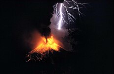 Eruption of Rinjani in 1984
 One of three different coloured lakes of Kelimutu


Comments
Post a Comment